Geolocate

Brunswick topographic map

Click on the map to display elevation.

About this map

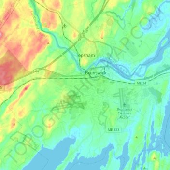
Name: Brunswick topographic map, elevation, terrain.

Location: Brunswick, Cumberland County, Maine, 04011, USA (43.85767 -70.02885 43.95335 -69.85707)

Average elevation: 89 ft

Minimum elevation: -10 ft

Maximum elevation: 328 ft

Gear up for your next adventure:

🔥Camping Stove - Portable stove for camping and backcountry cooking
🪵Folding Camp Saw - Compact saw for wood and campsite work
🪶Wildlife Field Guides - Learn animal tracking and species ID
🪶Fire Starter Kit - Reliable fire starter for survival and camping
🕶️Glacier Sunglasses - Side shields to protect eyes from high-altitude snow glare

As an Amazon Associate, this site earns from qualifying purchases at no extra cost to you.