Geolocate

Gangi topographic map

Click on the map to display elevation.

About this map

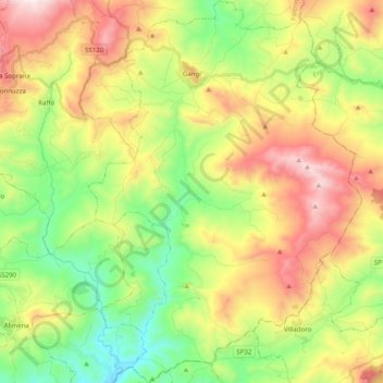
Name: Gangi topographic map, elevation, terrain.

Location: Gangi, Palermo, Sicily, 90024, Italy (37.66972 14.15173 37.82726 14.29439)

Average elevation: 2,631 ft

Minimum elevation: 1,306 ft

Maximum elevation: 4,498 ft

Other topographic maps

Click on a map to view its topography, its elevation and its terrain.

Sorgente di Montescuro

Italy > Sicily > Palermo > Prizzi

Average elevation: 2,726 ft

Bellacera

Italy > Sicily > Palermo > Santa Flavia

Average elevation: 531 ft

Finale

Italy > Sicily > Palermo

Average elevation: 276 ft

Santa Lucia

Italy > Sicily > Palermo > Cefalù

Average elevation: 167 ft

San Carlo

Italy > Sicily > Palermo > Chiusa Sclafani

Average elevation: 955 ft

Gear up for your next adventure:

🎒Outdoor Daypacks - Lightweight backpacks designed for carrying maps and essential gear
🛰️Handheld GPS Units - Professional satellite navigators for precise backcountry mapping
Backpacking Tents - Weight-optimized shelters for multi-day topographic surveys
🔭Stargazing Telescopes - Perfect for camping in low-light pollution areas shown on maps
⛑️Personal Locator Beacon - Safety beacon for emergencies

As an Amazon Associate, this site earns from qualifying purchases at no extra cost to you.