
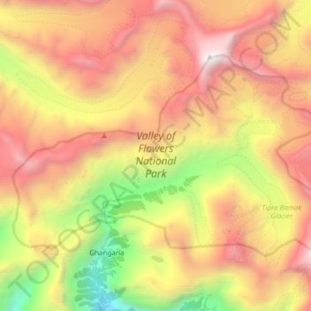
Valley of Flowers National Park topographic map
Interactive map
Click on the map to display elevation.
About this map
Name: Valley of Flowers National Park topographic map, elevation, terrain.
Average elevation: 15,112 ft
Minimum elevation: 8,724 ft
Maximum elevation: 21,030 ft
Other topographic maps
Click on a map to view its topography, its elevation and its terrain.
Dadon
India > Uttarakhand > Joshimath Tehsil > Joshimath
Dadon, Joshimath, Joshimath Tehsil, Chamoli district, Uttarakhand, India
Average elevation: 6,913 ft
Pangarchulla
India > Uttarakhand > Joshimath Tehsil
Pangarchulla, Joshimath Tehsil, Chamoli District, Uttarakhand, 246483, India
Average elevation: 13,323 ft
Joshimath
India > Uttarakhand > Joshimath Tehsil
Joshimath, Joshimath Tehsil, Chamoli district, Uttarakhand, India
Average elevation: 7,454 ft
Nanda Devi
India > Uttarakhand > Joshimath Tehsil
Nanda Devi, Joshimath Tehsil, Chamoli District, Uttarakhand, India
Average elevation: 21,545 ft
Pinola
India > Uttarakhand > Joshimath Tehsil > Govindghat > Pinola
Pinola, Govindghat, Joshimath Tehsil, Chamoli district, Uttarakhand, India
Average elevation: 8,051 ft
Hemkund
India > Uttarakhand > Joshimath Tehsil
Hemkund, Joshimath Tehsil, Chamoli district, Uttarakhand, India
Average elevation: 14,327 ft
Badrinath
India > Uttarakhand > Joshimath Tehsil
Badrinath, Joshimath Tehsil, Chamoli District, Uttarakhand, India
Average elevation: 13,294 ft