
السمارة topographic map
Interactive map
Click on the map to display elevation.
About this map
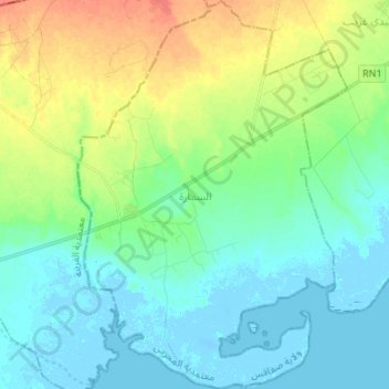
Name: السمارة topographic map, elevation, terrain.
Location: السمارة, معتمدية المحرس, Sfax, Tunisia (34.39626 10.27267 34.50695 10.36568)
Average elevation: 43 ft
Minimum elevation: -33 ft
Maximum elevation: 141 ft
Other topographic maps
Click on a map to view its topography, its elevation and its terrain.
سكرة
Tunisia > Sfax > معتمدية صفاقس الغربية
سكرة, معتمدية صفاقس الغربية, Sfax, 3003, Tunisia
Average elevation: 20 ft