Geolocate

Singasari topographic map

Click on the map to display elevation.

About this map

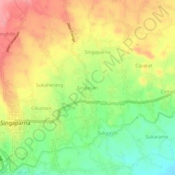
Name: Singasari topographic map, elevation, terrain.

Location: Singasari, Tasikmalaya, West Java, Java, 46417, Indonesia (-7.36190 108.10736 -7.32190 108.14736)

Average elevation: 1,378 ft

Minimum elevation: 1,198 ft

Maximum elevation: 1,549 ft

Other topographic maps

Click on a map to view its topography, its elevation and its terrain.

Cipanas

Indonesia > West Java > Tasikmalaya

Average elevation: 384 ft

Desa Arjasari

Indonesia > West Java > Tasikmalaya

Average elevation: 1,490 ft

Desa Cimanuk

Indonesia > West Java > Tasikmalaya

Average elevation: 105 ft

Gear up for your next adventure:

🛌Ultralight Sleeping Bags - Compact down bags for cold nights in the wilderness
🚪Portable Camp Chair - Foldable chair for comfort at camp
🥘Titanium Cookware - Durable, featherlight pots and pans for backpacking
📦Gear Storage Bags - Organize and protect outdoor equipment
👓Polarized Sunglasses - Outdoor sunglasses for glare reduction

As an Amazon Associate, this site earns from qualifying purchases at no extra cost to you.