
Make a donation
Gear up for your next adventure:
As an Amazon Associate, this site earns from qualifying purchases at no extra cost to you.
Gardanne topographic map
Click on the map to display elevation.
Make a donation
Gear up for your next adventure:
As an Amazon Associate, this site earns from qualifying purchases at no extra cost to you.
About this map
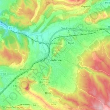
Name: Gardanne topographic map, elevation, terrain.
Average elevation: 837 ft
Minimum elevation: 512 ft
Maximum elevation: 1,276 ft
Make a donation
Gear up for your next adventure:
As an Amazon Associate, this site earns from qualifying purchases at no extra cost to you.
Other topographic maps
Click on a map to view its topography, its elevation and its terrain.
La Cride
Francia > Provenza-Alpes-Costa Azul > Bocas del Ródano > Le Puy-Sainte-Réparade > La Cride
Average elevation: 997 ft
Massane
Francia > Provenza-Alpes-Costa Azul > Bocas del Ródano > Saint-Mitre-les-Remparts
Average elevation: 105 ft
Make a donation
Gear up for your next adventure:
As an Amazon Associate, this site earns from qualifying purchases at no extra cost to you.