
Make a donation
Gear up for your next adventure:
As an Amazon Associate, this site earns from qualifying purchases at no extra cost to you.
Castellane topographic map
Click on the map to display elevation.
Make a donation
Gear up for your next adventure:
As an Amazon Associate, this site earns from qualifying purchases at no extra cost to you.
Castellane
Catellane's largest fountain, in the main square, features a pyramid on which is carved a compass crossed by a carpenter's square, two chisels and a mallet, emblems of the Freemasons. At the top of the pyramid is a pedestal with a ball. On National Street, two doors have transoms or capitals with volutes, and one lintel is decorated with carved foliage. In the town, several buildings, mostly dry stone, have been recorded in the inventory of topographic DRAC. One of them, in Rayaup, dates from the eighteenth century (the inscription that says 1586 is very recent).
Make a donation
Gear up for your next adventure:
As an Amazon Associate, this site earns from qualifying purchases at no extra cost to you.
About this map
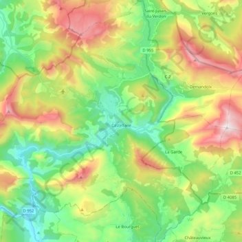
Name: Castellane topographic map, elevation, terrain.
Average elevation: 3,583 ft
Minimum elevation: 2,064 ft
Maximum elevation: 6,194 ft
Make a donation
Gear up for your next adventure:
As an Amazon Associate, this site earns from qualifying purchases at no extra cost to you.
Other topographic maps
Click on a map to view its topography, its elevation and its terrain.
La Gravette
France > Provence-Alpes-Côte d'Azur > Alpes-de-Haute-Provence > Barcelonnette
Average elevation: 4,206 ft
Chaumie Bas
France > Provence-Alpes-Côte d'Azur > Alpes-de-Haute-Provence > Chaumie
Average elevation: 5,502 ft
Digne-les-Bains
France > Provence-Alpes-Côte d'Azur > Alpes-de-Haute-Provence > Digne-les-Bains > Digne-les-Bains
Average elevation: 2,595 ft
Make a donation
Gear up for your next adventure:
As an Amazon Associate, this site earns from qualifying purchases at no extra cost to you.
Ouvrage de Haut-Saint-Ours
France > Provence-Alpes-Côte d'Azur > Alpes-de-Haute-Provence > Val-d'Oronaye > Saint-Ours
Average elevation: 6,329 ft
Saint-Ours
France > Provence-Alpes-Côte d'Azur > Alpes-de-Haute-Provence > Val-d'Oronaye > Saint-Ours
Average elevation: 6,663 ft
Fouillouse
France > Provence-Alpes-Côte d'Azur > Alpes-de-Haute-Provence > Saint-Paul-sur-Ubaye
Average elevation: 6,900 ft