
Make a donation
Gear up for your next adventure:
As an Amazon Associate, this site earns from qualifying purchases at no extra cost to you.
Kamenz - Kamjenc topographic map
Click on the map to display elevation.
Make a donation
Gear up for your next adventure:
As an Amazon Associate, this site earns from qualifying purchases at no extra cost to you.
Kamenz - Kamjenc
This small town is located in the west of the Upper Lusatia historic region (West Lusatia), about 40 km (25 mi) northeast of Dresden and about 30 km (19 mi) northwest of Bautzen. Situated on the Black Elster river, between the West Lusatian Hills and the Lusatian Highlands rising in the south, the town was built on greywacke and granite rocks which were mined here for centuries. Kamenz railway station is the terminus of Lübbenau–Kamenz and Kamenz–Pirna railway lines. It is served by Regionalbahn trains from Dresden Hauptbahnhof, operated by the Städtebahn Sachsen. The Hutberg hill west of the town centre, at an elevation of 293 m (961 ft), is the site of an extended landscape park laid out in 1893. It is known for its major rhododendron and azalea collections flowering at Pentecost. In 1864 the Lessing Tower was erected on the hilltop, offering a panoramic view over the West Lusatian lands and the Upper Lusatian Heath and Pond Landscape in the north. About 32% of the nature in former Kamenz District is under protection, including a network of routes for riding by bicycle and hiking.
Make a donation
Gear up for your next adventure:
As an Amazon Associate, this site earns from qualifying purchases at no extra cost to you.
About this map
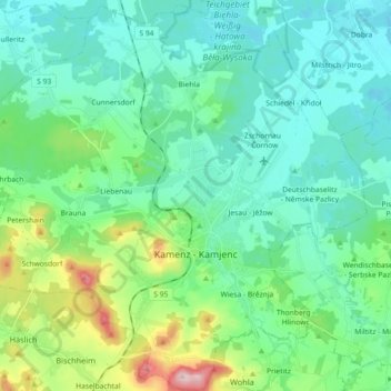
Name: Kamenz - Kamjenc topographic map, elevation, terrain.
Location: Kamenz - Kamjenc, Bautzen, Saxony, Germany (51.23001 13.99381 51.34336 14.17437)
Average elevation: 610 ft
Minimum elevation: 440 ft
Maximum elevation: 1,253 ft
Make a donation
Gear up for your next adventure:
As an Amazon Associate, this site earns from qualifying purchases at no extra cost to you.
Other topographic maps
Click on a map to view its topography, its elevation and its terrain.
Koselbruch - Kózło
Germany > Saxony > Bautzen > Hoyerswerda - Wojerecy > Schwarzkollm - Čorny Chołmc
Average elevation: 436 ft