Geolocate

Llanhennock topographic map

Click on the map to display elevation.

About this map

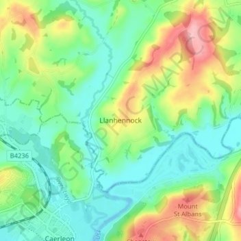
Name: Llanhennock topographic map, elevation, terrain.

Location: Llanhennock, Monmouthshire, Wales, NP18 1LT, United Kingdom (51.60912 -2.95779 51.64912 -2.91779)

Average elevation: 148 ft

Minimum elevation: 0 ft

Maximum elevation: 443 ft

Other topographic maps

Click on a map to view its topography, its elevation and its terrain.

Wye Valley

United Kingdom > Wales > Monmouthshire

Average elevation: 548 ft

Chepstow Castle

United Kingdom > Wales > Monmouthshire > Chepstow

Average elevation: 174 ft

Penallt

United Kingdom > Wales > Monmouthshire

Average elevation: 571 ft

Crucorney

United Kingdom > Wales > Monmouthshire

Average elevation: 974 ft

Blorenge

United Kingdom > Wales > Monmouthshire > Govilon

Average elevation: 1,293 ft

River Monnow

United Kingdom > Wales > Monmouthshire

Average elevation: 564 ft

Llanbadoc

United Kingdom > Wales > Monmouthshire

Average elevation: 256 ft

River Monnow

United Kingdom > Wales > Monmouthshire

Average elevation: 564 ft

Raglan Castle

United Kingdom > Wales > Monmouthshire > Raglan

Average elevation: 194 ft

Gear up for your next adventure:

🛡️Bear Spray Outdoor - Protection in bear country hikes
📡GPS Antenna Upgrade - Enhance GPS reception in remote terrain
🧭GPS Watch Accessories - Bands and chargers for GPS watches
🎒Trekking Poles - Sturdy poles for balance and stability on rough terrain
🧦Hiking Socks - Comfortable socks to prevent blisters on long hikes

As an Amazon Associate, this site earns from qualifying purchases at no extra cost to you.