
Make a donation
Gear up for your next adventure:
As an Amazon Associate, this site earns from qualifying purchases at no extra cost to you.
Riviera Beach topographic map
Click on the map to display elevation.
Make a donation
Gear up for your next adventure:
As an Amazon Associate, this site earns from qualifying purchases at no extra cost to you.
About this map
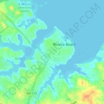
Name: Riviera Beach topographic map, elevation, terrain.
Location: Riviera Beach, Anne Arundel County, Maryland, United States (39.14461 -76.56275 39.17612 -76.50041)
Average elevation: 20 ft
Minimum elevation: -7 ft
Maximum elevation: 102 ft
Anne Arundel County trails, hiking, mountain biking, running and outdoor activities
Make a donation
Gear up for your next adventure:
As an Amazon Associate, this site earns from qualifying purchases at no extra cost to you.
Other topographic maps
Click on a map to view its topography, its elevation and its terrain.
Fort Smallwood Park
United States > Maryland > Anne Arundel County > Riviera Beach > Rockwood Beach
Average elevation: 7 ft