Geolocate

Russell Springs topographic map

Click on the map to display elevation.

About this map

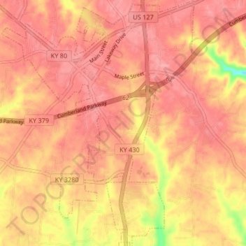
Name: Russell Springs topographic map, elevation, terrain.

Location: Russell Springs, Russell County, Kentucky, United States (37.01788 -85.10961 37.07086 -85.05765)

Average elevation: 1,040 ft

Minimum elevation: 823 ft

Maximum elevation: 1,109 ft

Russell County trails, hiking, mountain biking, running and outdoor activities

Other topographic maps

Click on a map to view its topography, its elevation and its terrain.

Ribbon

United States > Kentucky > Russell County

Average elevation: 669 ft

Rowena

United States > Kentucky > Russell County

Average elevation: 771 ft

Fonthill

United States > Kentucky > Russell County

Average elevation: 991 ft

Olga

United States > Kentucky > Russell County

Average elevation: 948 ft

Indian Hills

United States > Kentucky > Russell County

Average elevation: 856 ft

Whittle

United States > Kentucky > Russell County

Average elevation: 974 ft

Gear up for your next adventure:

🧭Outdoor Navigation Book - Learn advanced navigation skills
📖Nature Tracking Books - Learn to track wildlife and terrain
📡GPS Antenna Upgrade - Enhance GPS reception in remote terrain
🗻Climbing Gear Basics - Essential gear for beginner climbers
🧢Outdoor Hiking Hat - Sun protection hat for outdoor explorers

As an Amazon Associate, this site earns from qualifying purchases at no extra cost to you.