Geolocate

Bethel topographic map

Click on the map to display elevation.

About this map

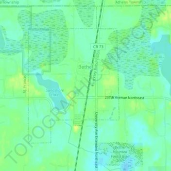
Name: Bethel topographic map, elevation, terrain.

Location: Bethel, Anoka County, Minnesota, United States (45.39207 -93.28073 45.41015 -93.26029)

Average elevation: 925 ft

Minimum elevation: 902 ft

Maximum elevation: 955 ft

Anoka County trails, hiking, mountain biking, running and outdoor activities

Other topographic maps

Click on a map to view its topography, its elevation and its terrain.

Filmore Park

United States > Minnesota > Anoka County > Blaine

Average elevation: 906 ft

Linwood

United States > Minnesota > Anoka County

Average elevation: 909 ft

Johnsville

United States > Minnesota > Anoka County > Blaine

Average elevation: 902 ft

Martin Lake

United States > Minnesota > Anoka County

Average elevation: 906 ft

Cedar

United States > Minnesota > Anoka County > Oak Grove

Average elevation: 899 ft

Island Lake

United States > Minnesota > Anoka County > Linwood

Average elevation: 909 ft

Gear up for your next adventure:

🥩Freeze-Dried Meals - Nutritious and lightweight food for remote expeditions
📡GPS Antenna Upgrade - Enhance GPS reception in remote terrain
⛑️Personal Locator Beacon - Safety beacon for emergencies
🔋Rechargeable Batteries - Power up your outdoor devices
🔥Plasma Lighters - Windproof lighters that work in any weather condition

As an Amazon Associate, this site earns from qualifying purchases at no extra cost to you.