Geolocate

Hemlock topographic map

Click on the map to display elevation.

About this map

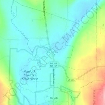
Name: Hemlock topographic map, elevation, terrain.

Location: Hemlock, Town of Livonia, Livingston County, New York, United States (42.77788 -77.62400 42.81022 -77.58982)

Average elevation: 1,001 ft

Minimum elevation: 876 ft

Maximum elevation: 1,322 ft

Livingston County trails, hiking, mountain biking, running and outdoor activities

Other topographic maps

Click on a map to view its topography, its elevation and its terrain.

Dansville

United States > New York > Livingston County > Dansville

Average elevation: 909 ft

Idaho

United States > New York > Livingston County > Town of Lima > Idaho

Average elevation: 860 ft

Sonyea

United States > New York > Livingston County

Average elevation: 650 ft

Pine Tavern

United States > New York > Livingston County

Average elevation: 928 ft

Gear up for your next adventure:

🔋Solar Power Banks - Keep your GPS and phone charged in remote wilderness areas
🎒Hydration Pack - Hands‑free water reservoir for long hikes
🕶️Glacier Sunglasses - Side shields to protect eyes from high-altitude snow glare
GPS Sports Watch - GPS watch for running, hiking and training
🔭Telescopic Hiking Pole - Adjustable pole for hiking stability

As an Amazon Associate, this site earns from qualifying purchases at no extra cost to you.