
Make a donation
Gear up for your next adventure:
As an Amazon Associate, this site earns from qualifying purchases at no extra cost to you.
Lake Dey-Dey topographic map
Click on the map to display elevation.
Make a donation
Gear up for your next adventure:
As an Amazon Associate, this site earns from qualifying purchases at no extra cost to you.
Lake Dey-Dey
The surface of the lake normally consists of dry clay, silt or sand, covered with a salty crust. The area around Lake Dey Dey is extremely arid, and groundwater contains high levels of salinity. The elevation of the surface above mean sea level is 208 m (682 ft).
Make a donation
Gear up for your next adventure:
As an Amazon Associate, this site earns from qualifying purchases at no extra cost to you.
About this map
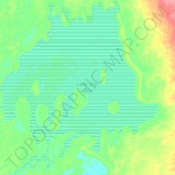
Name: Lake Dey-Dey topographic map, elevation, terrain.
Average elevation: 719 ft
Minimum elevation: 650 ft
Maximum elevation: 912 ft
Make a donation
Gear up for your next adventure:
As an Amazon Associate, this site earns from qualifying purchases at no extra cost to you.
Other topographic maps
Click on a map to view its topography, its elevation and its terrain.