
Make a donation
Gear up for your next adventure:
As an Amazon Associate, this site earns from qualifying purchases at no extra cost to you.
Gal Oya topographic map
Click on the map to display elevation.
Make a donation
Gear up for your next adventure:
As an Amazon Associate, this site earns from qualifying purchases at no extra cost to you.
About this map
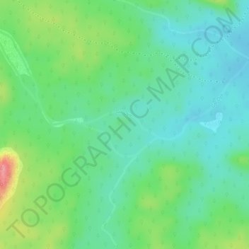
Name: Gal Oya topographic map, elevation, terrain.
Location: Gal Oya, Monaragala District, Uva Province, Sri Lanka (7.17567 81.39085 7.17856 81.39933)
Average elevation: 463 ft
Minimum elevation: 348 ft
Maximum elevation: 696 ft
Make a donation
Gear up for your next adventure:
As an Amazon Associate, this site earns from qualifying purchases at no extra cost to you.
Other topographic maps
Click on a map to view its topography, its elevation and its terrain.
Bandarawela
Bandarawela (Sinhala : බණ්ඩාරවෙල, pronounced [ˈbandarawela]; Tamil: பண்டாரவெல) is the second largest town in the Badulla District which is 28 km (17 mi) away from Badulla. Bandarawela is 200 km (120 mi) away from Colombo and about 125 km (78 mi) away from Kandy, the two…
Average elevation: 4,242 ft
Make a donation
Gear up for your next adventure:
As an Amazon Associate, this site earns from qualifying purchases at no extra cost to you.
Make a donation
Gear up for your next adventure:
As an Amazon Associate, this site earns from qualifying purchases at no extra cost to you.
Make a donation
Gear up for your next adventure:
As an Amazon Associate, this site earns from qualifying purchases at no extra cost to you.