
Make a donation
Gear up for your next adventure:
As an Amazon Associate, this site earns from qualifying purchases at no extra cost to you.
Haidemühl topographic map
Click on the map to display elevation.
Make a donation
Gear up for your next adventure:
As an Amazon Associate, this site earns from qualifying purchases at no extra cost to you.
Haidemühl
Am westlichen Ortsrand von Haidemühl entstand 2006 ein 25,5 Meter hoher Aussichtsturm. Die Konstruktion besteht aus einer Spindeltreppe die zu drei versetzt zueinander stehenden Aussichtsplattformen führt. Die höchste Plattform befindet sich auf einer Höhe von 18 Metern.
Make a donation
Gear up for your next adventure:
As an Amazon Associate, this site earns from qualifying purchases at no extra cost to you.
About this map
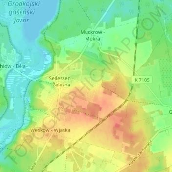
Name: Haidemühl topographic map, elevation, terrain.
Average elevation: 377 ft
Minimum elevation: 299 ft
Maximum elevation: 486 ft
Make a donation
Gear up for your next adventure:
As an Amazon Associate, this site earns from qualifying purchases at no extra cost to you.
Other topographic maps
Click on a map to view its topography, its elevation and its terrain.