
Balkuru topographic map
Interactive map
Click on the map to display elevation.
About this map
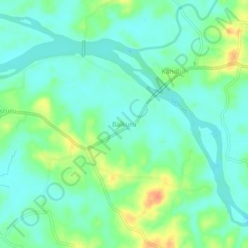
Name: Balkuru topographic map, elevation, terrain.
Location: Balkuru, Kundapura, Udupi District, Karnataka, 576211, India (13.60868 74.73667 13.64868 74.77667)
Average elevation: 46 ft
Minimum elevation: 0 ft
Maximum elevation: 141 ft
Other topographic maps
Click on a map to view its topography, its elevation and its terrain.
Kodi beach
India > Karnataka > Kundapura > Kundapura
Kodi beach, Church Road, Vaderahobali, Kundapura, Udupi district, Karnataka, 576200, India
Average elevation: 7 ft
Shankaranarayana
Shankaranarayana, Kundapura, Udupi District, Karnataka, 576227, India
Average elevation: 141 ft