Geolocate

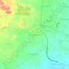
Cibeureum topographic map

Click on the map to display elevation.

About this map

Name: Cibeureum topographic map, elevation, terrain.

Location: Cibeureum, Tasikmalaya, West Java, Indonesia (-7.37682 108.22846 -7.33682 108.28840)

Average elevation: 1,086 ft

Minimum elevation: 725 ft

Maximum elevation: 1,234 ft

Other topographic maps

Click on a map to view its topography, its elevation and its terrain.
Mangkubumi

Indonesia > West Java > Tasikmalaya

Average elevation: 1,214 ft

Gear up for your next adventure:

🧢Sun Protection Hats - Wide-brimmed and UPF-rated hats for high-altitude sun safety
🔥Camping Stove - Portable stove for camping and backcountry cooking
🌡️Portable Weather Meter - Track weather conditions on the trail
📻Weather Alert Radios - Stay informed of storm risks while off-the-grid
🔦Compact Flashlight - Reliable flashlight for emergencies

As an Amazon Associate, this site earns from qualifying purchases at no extra cost to you.