Geolocate

Khamanon topographic map

Click on the map to display elevation.

Khamanon

Khamanon is located at 30°49′N 76°21′E / 30.82°N 76.35°E / 30.82; 76.35. It has an average elevation of 254 metres (833 feet).

Wikipedia (CC-BY-SA 3.0)

About this map

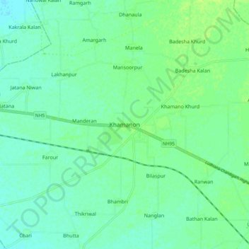
Name: Khamanon topographic map, elevation, terrain.

Location: Khamanon, Khamanon Tahsil, Fategarh Sahib, Punjab, 141801, India (30.77635 76.29860 30.85635 76.37860)

Average elevation: 899 ft

Minimum elevation: 883 ft

Maximum elevation: 919 ft

Gear up for your next adventure:

🥩Freeze-Dried Meals - Nutritious and lightweight food for remote expeditions
🛰️Satellite Messengers - Emergency SOS and two-way messaging for off-grid adventures
💧Water Filtration Bottles - Safely drink from streams and lakes while exploring
🌡️Portable Weather Meter - Track weather conditions on the trail
🪶Camp Gear Gift Set - Perfect gift bundle for outdoor fans

As an Amazon Associate, this site earns from qualifying purchases at no extra cost to you.