Geolocate

Kitwanga topographic map

Click on the map to display elevation.

About this map

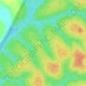
Name: Kitwanga topographic map, elevation, terrain.

Location: Kitwanga, Kiryandongo, Western Region, Uganda (1.96855 31.99110 2.00855 32.03110)

Average elevation: 3,579 ft

Minimum elevation: 3,507 ft

Maximum elevation: 3,665 ft

Gear up for your next adventure:

🪶Survival Guide Book - Expert advice for emergency preparedness
🔦LED Headlamp - Bright and durable LED headlamp for night navigation
🔥Plasma Lighters - Windproof lighters that work in any weather condition
🪄Magnetic Compass - Accurate compass for navigation
🧭Pro Hiking Compasses - High-accuracy liquid-filled compasses for topographic orientation

As an Amazon Associate, this site earns from qualifying purchases at no extra cost to you.