
Make a donation
Gear up for your next adventure:
As an Amazon Associate, this site earns from qualifying purchases at no extra cost to you.
Rietspruit Dam topographic map
Click on the map to display elevation.
Make a donation
Gear up for your next adventure:
As an Amazon Associate, this site earns from qualifying purchases at no extra cost to you.
About this map
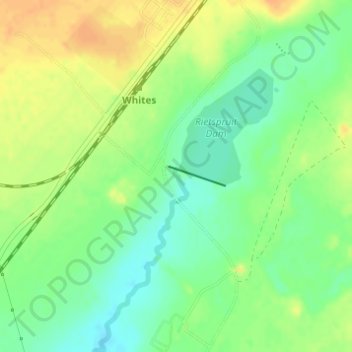
Name: Rietspruit Dam topographic map, elevation, terrain.
Average elevation: 4,475 ft
Minimum elevation: 4,423 ft
Maximum elevation: 4,528 ft
Make a donation
Gear up for your next adventure:
As an Amazon Associate, this site earns from qualifying purchases at no extra cost to you.
Other topographic maps
Click on a map to view its topography, its elevation and its terrain.
Bronville
South Africa > Free State > Lejweleputswa District Municipality > Matjhabeng Local Municipality
Average elevation: 4,478 ft
Harmony
South Africa > Free State > Lejweleputswa District Municipality > Matjhabeng Local Municipality
Average elevation: 4,373 ft
Highveld
South Africa > Free State > Lejweleputswa District Municipality > Matjhabeng Local Municipality
Average elevation: 4,528 ft
Huis Ougoud Retirement Village
South Africa > Free State > Lejweleputswa District Municipality > Matjhabeng Local Municipality
Average elevation: 4,426 ft
Make a donation
Gear up for your next adventure:
As an Amazon Associate, this site earns from qualifying purchases at no extra cost to you.
Riebeeckstad
South Africa > Free State > Lejweleputswa District Municipality > Matjhabeng Local Municipality
Average elevation: 4,541 ft