
Thank you for supporting this site ❤️
Make a donation
Make a donation
Gear up for your next adventure:
As an Amazon Associate, this site earns from qualifying purchases at no extra cost to you.
Gukguk Aek Raja topographic map
Click on the map to display elevation.
Thank you for supporting this site ❤️
Make a donation
Make a donation
Gear up for your next adventure:
As an Amazon Associate, this site earns from qualifying purchases at no extra cost to you.
About this map
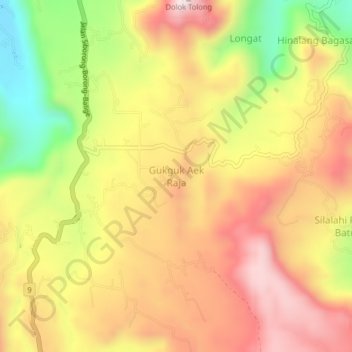
Name: Gukguk Aek Raja topographic map, elevation, terrain.
Location: Gukguk Aek Raja, Toba Samosir, North Sumatra, 22312, Indonesia (2.28318 99.00450 2.32318 99.04450)
Average elevation: 4,049 ft
Minimum elevation: 2,982 ft
Maximum elevation: 4,872 ft
Thank you for supporting this site ❤️
Make a donation
Make a donation
Gear up for your next adventure:
As an Amazon Associate, this site earns from qualifying purchases at no extra cost to you.