
Thank you for supporting this site ❤️
Make a donation
Make a donation
Gear up for your next adventure:
As an Amazon Associate, this site earns from qualifying purchases at no extra cost to you.
Maddalena topographic map
Click on the map to display elevation.
Thank you for supporting this site ❤️
Make a donation
Make a donation
Gear up for your next adventure:
As an Amazon Associate, this site earns from qualifying purchases at no extra cost to you.
About this map
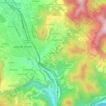
Name: Maddalena topographic map, elevation, terrain.
Location: Maddalena, Cava de' Tirreni, Salerno, Campania, 84013, Italia (40.67803 14.70130 40.71803 14.74130)
Average elevation: 965 ft
Minimum elevation: 75 ft
Maximum elevation: 2,152 ft
Thank you for supporting this site ❤️
Make a donation
Make a donation
Gear up for your next adventure:
As an Amazon Associate, this site earns from qualifying purchases at no extra cost to you.