
Make a donation
Gear up for your next adventure:
As an Amazon Associate, this site earns from qualifying purchases at no extra cost to you.
Romansthal topographic map
Click on the map to display elevation.
Make a donation
Gear up for your next adventure:
As an Amazon Associate, this site earns from qualifying purchases at no extra cost to you.
Romansthal
Das Dorf liegt etwa 2,5 Kilometer östlich von Bad Staffelstein auf einer Anhöhe am Fuß des Staffelbergs. In zwei Kilometer Entfernung führt die Autobahn 73 vorbei.
Make a donation
Gear up for your next adventure:
As an Amazon Associate, this site earns from qualifying purchases at no extra cost to you.
About this map
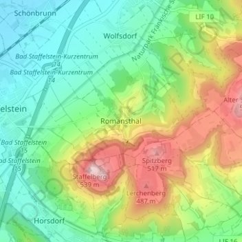
Name: Romansthal topographic map, elevation, terrain.
Average elevation: 1,155 ft
Minimum elevation: 833 ft
Maximum elevation: 1,745 ft
Make a donation
Gear up for your next adventure:
As an Amazon Associate, this site earns from qualifying purchases at no extra cost to you.
Other topographic maps
Click on a map to view its topography, its elevation and its terrain.
https://www.regierung.oberfranken.bayern.de/nsg/5-35/5-35-02-Verordnung.pdf
Deutschland > Bayern > Landkreis Lichtenfels > Bad Staffelstein > Romansthal
Average elevation: 1,181 ft
Trimeusel
Deutschland > Bayern > Landkreis Lichtenfels > Bad Staffelstein > Nedensdorf
Average elevation: 945 ft