Geolocate

Tauru topographic map

Click on the map to display elevation.

Tauru

Taoru is located at 28°13′N 76°57′E / 28.22°N 76.95°E / 28.22; 76.95. It has an average elevation of 262 metres (859 feet). It is surrounded by Aravalli Range from three sides.

Wikipedia (CC-BY-SA 3.0)

About this map

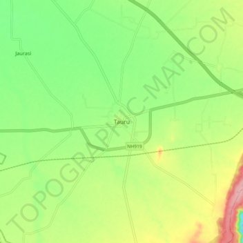
Name: Tauru topographic map, elevation, terrain.

Location: Tauru, Taoru, Nuh District, Haryana, 122105, India (28.17093 76.91064 28.25093 76.99064)

Average elevation: 876 ft

Minimum elevation: 692 ft

Maximum elevation: 1,148 ft

Gear up for your next adventure:

🪶Wildlife Field Guides - Learn animal tracking and species ID
🔌USB Car Charger - Car charger for on‑the‑go power needs
🎒Day Hiking Backpack - Lightweight backpack perfect for day trips and outdoor adventures
🎒Trail Energy Bars - High‑calorie bars for hiking energy
🎁Geography Themed Gifts - Unique gift ideas for map lovers and geography enthusiasts

As an Amazon Associate, this site earns from qualifying purchases at no extra cost to you.