
Make a donation
Gear up for your next adventure:
As an Amazon Associate, this site earns from qualifying purchases at no extra cost to you.
Bergheim topographic map
Click on the map to display elevation.
Make a donation
Gear up for your next adventure:
As an Amazon Associate, this site earns from qualifying purchases at no extra cost to you.
About this map
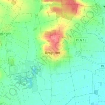
Name: Bergheim topographic map, elevation, terrain.
Average elevation: 1,470 ft
Minimum elevation: 1,394 ft
Maximum elevation: 1,647 ft
Make a donation
Gear up for your next adventure:
As an Amazon Associate, this site earns from qualifying purchases at no extra cost to you.
Other topographic maps
Click on a map to view its topography, its elevation and its terrain.
Bächingen a.d.Brenz
Deutschland > Bayern > Landkreis Dillingen an der Donau
Average elevation: 1,450 ft
Glött
Deutschland > Bayern > Landkreis Dillingen an der Donau
Im August 2007 wurde in Glött die erste Windkraftanlage im Landkreis Dillingen errichtet. Es handelt sich dabei um eine Enercon E-53 mit Nabenhöhe 73 m, Rotordurchmesser 53 m und einer Leistung von 800 kW.
Average elevation: 1,493 ft
Dillingen a.d.Donau
Deutschland > Bayern > Landkreis Dillingen an der Donau
Average elevation: 1,411 ft
Wertingen
Deutschland > Bayern > Landkreis Dillingen an der Donau
Die Stadt an der unteren Zusam, die wenige Kilometer nördlich in die Donau mündet, wird von einem langgezogenen Höhenrücken vom Donauried getrennt. Wertingen liegt im großen Naturpark Augsburg-Westliche Wälder, der von den Flüssen Donau, Lech, Wertach und Mindel begrenzt wird. Augsburg ist 28 km,…
Average elevation: 1,460 ft
Make a donation
Gear up for your next adventure:
As an Amazon Associate, this site earns from qualifying purchases at no extra cost to you.
89415
Deutschland > Bayern > Landkreis Dillingen an der Donau > Lauingen (Donau)
Average elevation: 1,414 ft
Make a donation
Gear up for your next adventure:
As an Amazon Associate, this site earns from qualifying purchases at no extra cost to you.
Make a donation
Gear up for your next adventure:
As an Amazon Associate, this site earns from qualifying purchases at no extra cost to you.
Gundelfingen an der Donau (VGem)
Deutschland > Bayern > Landkreis Dillingen an der Donau
Average elevation: 1,483 ft
Aislingen
Deutschland > Bayern > Landkreis Dillingen an der Donau
Auf den südlichen Höhen befand sich ein römisches Erdkastell, unter dem Kaiser Tiberius errichtet, das etwa 68/69 n. Chr. zerstört wurde. In der Nähe wurde 1989/90 ein römisches Lagerdorf ergraben. An der heutigen westlichen Flurgrenze verlief auf rund drei Kilometer eine römische Straße, die bei…
Average elevation: 1,483 ft
Make a donation
Gear up for your next adventure:
As an Amazon Associate, this site earns from qualifying purchases at no extra cost to you.
89423
Deutschland > Bayern > Landkreis Dillingen an der Donau > Gundelfingen an der Donau > Peterswörth
Average elevation: 1,450 ft
Make a donation
Gear up for your next adventure:
As an Amazon Associate, this site earns from qualifying purchases at no extra cost to you.
Gundelfingen an der Donau
Deutschland > Bayern > Landkreis Dillingen an der Donau
Average elevation: 1,450 ft
89420
Deutschland > Bayern > Landkreis Dillingen an der Donau > Höchstädt an der Donau
Average elevation: 1,440 ft
Höchstädt an der Donau
Deutschland > Bayern > Landkreis Dillingen an der Donau
Average elevation: 1,444 ft
Make a donation
Gear up for your next adventure:
As an Amazon Associate, this site earns from qualifying purchases at no extra cost to you.
Blindheim
Deutschland > Bayern > Landkreis Dillingen an der Donau
2014 gab es nach der amtlichen Statistik 108 sozialversicherungspflichtig Beschäftigte am Arbeitsort Blindheim, davon waren 77 im produzierenden Gewerbe tätig. Sozialversicherungspflichtig Beschäftigte am Wohnort gab es 717. Die Zahl der Auspendler war um 609 höher als die der Einpendler. Fünf Einwohner…
Average elevation: 1,424 ft
Lutzingen
Deutschland > Bayern > Landkreis Dillingen an der Donau
Im Jahr 2021 gab es nach der amtlichen Statistik 53 sozialversicherungspflichtig Beschäftigte am Arbeitsort Lutzingen. Sozialversicherungspflichtig Beschäftigte am Wohnort gab es 445. Die Zahl der Auspendler war um 392 höher als die der Einpendler. Neun Einwohner waren arbeitslos gemeldet. Im Jahr 2020 gab…
Average elevation: 1,565 ft
Dillingen a.d.Donau
Deutschland > Bayern > Landkreis Dillingen an der Donau
Average elevation: 1,411 ft
Make a donation
Gear up for your next adventure:
As an Amazon Associate, this site earns from qualifying purchases at no extra cost to you.
Höchstädt an der Donau
Deutschland > Bayern > Landkreis Dillingen an der Donau
Average elevation: 1,444 ft
Wertingen
Deutschland > Bayern > Landkreis Dillingen an der Donau
Die Stadt an der unteren Zusam, die wenige Kilometer nördlich in die Donau mündet, wird von einem langgezogenen Höhenrücken vom Donauried getrennt. Wertingen liegt im großen Naturpark Augsburg-Westliche Wälder, der von den Flüssen Donau, Lech, Wertach und Mindel begrenzt wird. Augsburg ist 28 km,…
Average elevation: 1,463 ft