
Make a donation
Gear up for your next adventure:
As an Amazon Associate, this site earns from qualifying purchases at no extra cost to you.
Uelhs deth Joeu topographic map
Click on the map to display elevation.
Make a donation
Gear up for your next adventure:
As an Amazon Associate, this site earns from qualifying purchases at no extra cost to you.
About this map
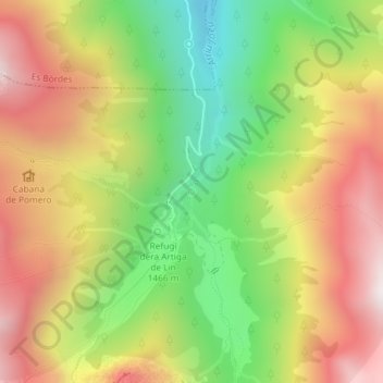
Name: Uelhs deth Joeu topographic map, elevation, terrain.
Average elevation: 5,554 ft
Minimum elevation: 3,888 ft
Maximum elevation: 7,257 ft
Make a donation
Gear up for your next adventure:
As an Amazon Associate, this site earns from qualifying purchases at no extra cost to you.
Other topographic maps
Click on a map to view its topography, its elevation and its terrain.
Barranc dera Montanya de Delà
España > Cataluña > Valle de Arán > Viella Mitg Arán
Average elevation: 5,016 ft
Era Bassa d'Oles
España > Cataluña > Valle de Arán > Viella Mitg Arán
La Bassa d'Oles es un lago de origen natural situado a 1600 metros de altitud en las proximidades de Viella, en la comarca del Valle de Arán . Está ubicada en el entorno del bosque de Baricauba, a los pies del pico de Montcorbison.
Average elevation: 4,685 ft