Geolocate

Châtel-Censoir topographic map

Click on the map to display elevation.

About this map
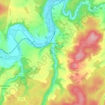
Name: Châtel-Censoir topographic map, elevation, terrain.

Location: Châtel-Censoir, Avallon, Yonne, Bourgogne – Franche-Comté, Metropolitan France, 89660, France (47.49491 3.59341 47.55799 3.67361)

Average elevation: 633 ft

Minimum elevation: 410 ft

Maximum elevation: 922 ft

Other topographic maps

Click on a map to view its topography, its elevation and its terrain.

Les Huees

France > Bourgogne – Franche-Comté > Yonne > Tonnerre

Average elevation: 748 ft

Sixte

France > Bourgogne – Franche-Comté > Yonne > Michery

Average elevation: 230 ft

Anus

France > Bourgogne – Franche-Comté > Yonne > Fouronnes

Average elevation: 758 ft

L'Ormeau

France > Bourgogne – Franche-Comté > Yonne > Vaudeurs

Average elevation: 705 ft

Bapaume

France > Bourgogne – Franche-Comté > Yonne > Dollot

Average elevation: 489 ft

Crai

France > Bourgogne – Franche-Comté > Yonne > Chamoux

Average elevation: 807 ft

Gear up for your next adventure:

🌡️Handheld Weather Meters - Measure wind, temp, and pressure for safe mountain travel
🧥Men's Rain Shells - Premium waterproof and breathable jackets for mountain weather
📱Heavy-Duty Phone Cases - Drop-proof and waterproof protection for outdoor navigation
📦Dry Bags Set - Waterproof storage for electronics and clothes
🚗GPS Dash Cams - Record your scenic drives through mountain passes and canyons

As an Amazon Associate, this site earns from qualifying purchases at no extra cost to you.