
Gams bei Hieflau topographic map
Interactive map
Click on the map to display elevation.
About this map
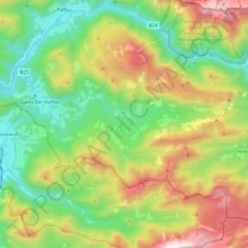
Name: Gams bei Hieflau topographic map, elevation, terrain.
Average elevation: 3,225 ft
Minimum elevation: 1,516 ft
Maximum elevation: 6,217 ft
Other topographic maps
Click on a map to view its topography, its elevation and its terrain.
Mooslandl
Oostenrijk > Stiermarken > Bezirk Liezen > Landl
Mooslandl, Landl, Bezirk Liezen, Stiermarken, 8931, Oostenrijk
Average elevation: 2,116 ft