Geolocate

Marabamba topographic map

Click on the map to display elevation.

About this map

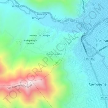
Name: Marabamba topographic map, elevation, terrain.

Location: Marabamba, Huánuco, 10061, Perú (-9.96982 -76.28325 -9.92982 -76.24325)

Average elevation: 7,024 ft

Minimum elevation: 6,207 ft

Maximum elevation: 9,587 ft

Other topographic maps

Click on a map to view its topography, its elevation and its terrain.

Parque Amarilis

Perú > Huánuco > Huánuco

Average elevation: 6,430 ft

Parque Puelles

Perú > Huánuco > Huánuco

Average elevation: 6,549 ft

Gear up for your next adventure:

🎁Geography Themed Gifts - Unique gift ideas for map lovers and geography enthusiasts
📖Nature Tracking Books - Learn to track wildlife and terrain
🕶️Glacier Sunglasses - Side shields to protect eyes from high-altitude snow glare
🖼️Topo Map Wall Art - Decorative topographic prints of famous peaks and regions
🛰️Handheld GPS Units - Professional satellite navigators for precise backcountry mapping

As an Amazon Associate, this site earns from qualifying purchases at no extra cost to you.