Geolocate

Braddock topographic map

Click on the map to display elevation.

About this map

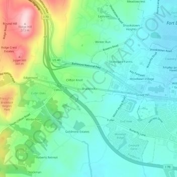
Name: Braddock topographic map, elevation, terrain.

Location: Braddock, Frederick County, Maryland, 21714, United States (39.40094 -77.49695 39.44094 -77.45695)

Average elevation: 571 ft

Minimum elevation: 335 ft

Maximum elevation: 1,211 ft

Frederick County trails, hiking, mountain biking, running and outdoor activities

Other topographic maps

Click on a map to view its topography, its elevation and its terrain.

Woodsboro

United States > Maryland > Frederick County

Average elevation: 404 ft

Clover Hill

United States > Maryland > Frederick County

Average elevation: 364 ft

Burkittsville

United States > Maryland > Frederick County

Average elevation: 610 ft

Rosemont

United States > Maryland > Frederick County

Average elevation: 449 ft

Green Valley

United States > Maryland > Frederick County

Average elevation: 505 ft

Flat Run

United States > Maryland > Frederick County > Emmitsburg

Average elevation: 453 ft

New Market

United States > Maryland > Frederick County

Average elevation: 499 ft

Gear up for your next adventure:

🌐World Map Poster - Decorative world maps with topographic info
📷Action Cameras - Rugged cameras to document your journeys across rugged terrain
🚁Photography Drones - Capture stunning aerial views of landforms and topography
🔪Outdoor Multitools - Essential survival tools for gear repair and field use
💧Water Filtration Bottles - Safely drink from streams and lakes while exploring

As an Amazon Associate, this site earns from qualifying purchases at no extra cost to you.