Geolocate

Guangling County topographic map

Click on the map to display elevation.

About this map

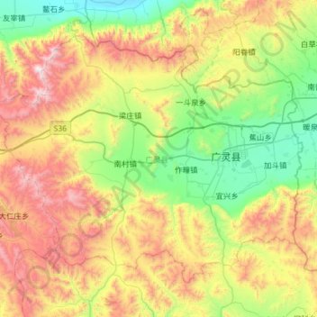
Name: Guangling County topographic map, elevation, terrain.

Location: Guangling County, Datong City, Shanxi, China (39.58863 113.84398 39.92978 114.41173)

Average elevation: 4,672 ft

Minimum elevation: 2,838 ft

Maximum elevation: 7,920 ft

Other topographic maps

Click on a map to view its topography, its elevation and its terrain.

Yungang Grottoes

China > Shanxi > Datong City > Yungang

Average elevation: 3,819 ft

Gear up for your next adventure:

📖Nature Tracking Books - Learn to track wildlife and terrain
🚑Emergency Bivvies - Heat-reflective sleeping bags for survival situations
🧯Portable Fire Pit - Compact fire pit for camping spots
🛌Ultralight Sleeping Bags - Compact down bags for cold nights in the wilderness
🛡️Bear Spray Outdoor - Protection in bear country hikes

As an Amazon Associate, this site earns from qualifying purchases at no extra cost to you.