
Saharanpur topographic map
Interactive map
Click on the map to display elevation.
About this map
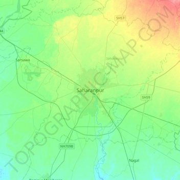
Name: Saharanpur topographic map, elevation, terrain.
Location: Saharanpur, Uttar Pradesh, 247001, India (29.80374 77.38275 30.12374 77.70275)
Average elevation: 909 ft
Minimum elevation: 850 ft
Maximum elevation: 1,056 ft
Other topographic maps
Click on a map to view its topography, its elevation and its terrain.
Hindon
India > Uttar Pradesh > Saharanpur
Hindon, Saharanpur, Uttar Pradesh, 247001, India
Average elevation: 850 ft