
Make a donation
Gear up for your next adventure:
As an Amazon Associate, this site earns from qualifying purchases at no extra cost to you.
Pinzolo topographic map
Click on the map to display elevation.
Make a donation
Gear up for your next adventure:
As an Amazon Associate, this site earns from qualifying purchases at no extra cost to you.
Pinzolo
Pinzolo (Eastern Lombard: Pinsöl) is a small town and comune situated in Val Rendena in Trentino in the northern Italian Alps at an elevation of 800 metres (2,600 ft). The Church of Saint Vigilius of Trent stands in the town.
Make a donation
Gear up for your next adventure:
As an Amazon Associate, this site earns from qualifying purchases at no extra cost to you.
About this map
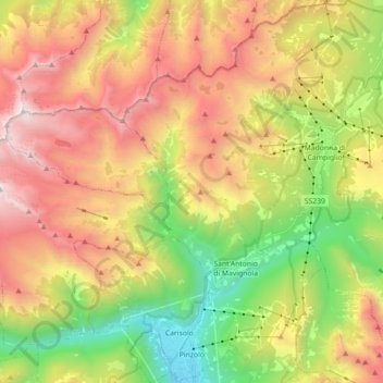
Name: Pinzolo topographic map, elevation, terrain.
Average elevation: 6,312 ft
Minimum elevation: 2,467 ft
Maximum elevation: 10,702 ft
Make a donation
Gear up for your next adventure:
As an Amazon Associate, this site earns from qualifying purchases at no extra cost to you.
Other topographic maps
Click on a map to view its topography, its elevation and its terrain.
Canale
Italy > Trentino – Alto Adige/Südtirol > Provincia di Trento > Tenno > Ville Del Monte
Average elevation: 2,326 ft
Povo
Italy > Trentino – Alto Adige/Südtirol > Provincia di Trento > Trento
Average elevation: 1,631 ft
Make a donation
Gear up for your next adventure:
As an Amazon Associate, this site earns from qualifying purchases at no extra cost to you.
Cortina
Italy > Trentino – Alto Adige/Südtirol > Provincia di Trento > Vermiglio
Average elevation: 5,033 ft
Val di Fiemme
Italy > Trentino – Alto Adige/Südtirol > Provincia di Trento > Panchià
Average elevation: 5,381 ft
Make a donation
Gear up for your next adventure:
As an Amazon Associate, this site earns from qualifying purchases at no extra cost to you.
Madonna di Campiglio
Italy > Trentino – Alto Adige/Südtirol > Provincia di Trento
Madonna di Campiglio (German: Sankt Maria im Pein) is a village and a ski resort in northeast Italy. It is a frazione of the comune of Pinzolo. The village lies in the Val Rendena at an elevation of 1,522 m (4,993 ft) above sea level, and has approximately 1,000 inhabitants.
Average elevation: 5,722 ft
Cortina
Italy > Trentino – Alto Adige/Südtirol > Provincia di Trento > Vermiglio
Average elevation: 5,033 ft
Covelo
Italy > Trentino – Alto Adige/Südtirol > Provincia di Trento > Vallelaghi
Average elevation: 2,736 ft
Make a donation
Gear up for your next adventure:
As an Amazon Associate, this site earns from qualifying purchases at no extra cost to you.
Vigo Cavedine
Italy > Trentino – Alto Adige/Südtirol > Provincia di Trento
Average elevation: 2,503 ft
Lago di Molveno
Italy > Trentino – Alto Adige/Südtirol > Provincia di Trento > Molveno
Average elevation: 3,514 ft
Make a donation
Gear up for your next adventure:
As an Amazon Associate, this site earns from qualifying purchases at no extra cost to you.
Ravina
Italy > Trentino – Alto Adige/Südtirol > Provincia di Trento > Trento
Average elevation: 1,368 ft
Bocca di Valle
Italy > Trentino – Alto Adige/Südtirol > Provincia di Trento > Bondone
Average elevation: 4,127 ft
Madonna di Campiglio
Italy > Trentino – Alto Adige/Südtirol > Provincia di Trento
Madonna di Campiglio (German: Sankt Maria im Pein) is a village and a ski resort in northeast Italy. It is a frazione of the comune of Pinzolo. The village lies in the Val Rendena at an elevation of 1,522 m (4,993 ft) above sea level, and has approximately 1,000 inhabitants.
Average elevation: 5,722 ft
Make a donation
Gear up for your next adventure:
As an Amazon Associate, this site earns from qualifying purchases at no extra cost to you.
Alpe Cermis
Italy > Trentino – Alto Adige/Südtirol > Provincia di Trento > Cavalese
Average elevation: 5,627 ft
Ronchi
Italy > Trentino – Alto Adige/Südtirol > Provincia di Trento > Trento > Mattarello
Average elevation: 1,112 ft
Belvedere
Italy > Trentino – Alto Adige/Südtirol > Provincia di Trento > Pergine Valsugana
Average elevation: 2,595 ft
Make a donation
Gear up for your next adventure:
As an Amazon Associate, this site earns from qualifying purchases at no extra cost to you.
Make a donation
Gear up for your next adventure:
As an Amazon Associate, this site earns from qualifying purchases at no extra cost to you.
Valsorda
Italy > Trentino – Alto Adige/Südtirol > Provincia di Trento > Predazzo
Average elevation: 5,856 ft
Biacesa di Ledro
Italy > Trentino – Alto Adige/Südtirol > Provincia di Trento
Average elevation: 2,726 ft
Cortina
Italy > Trentino – Alto Adige/Südtirol > Provincia di Trento > Vermiglio
Average elevation: 5,033 ft
Make a donation
Gear up for your next adventure:
As an Amazon Associate, this site earns from qualifying purchases at no extra cost to you.
Saone
Italy > Trentino – Alto Adige/Südtirol > Provincia di Trento > Tione di Trento
Average elevation: 2,782 ft
Karerpass - Jouf de Ciareja - passo Carezza
Italy > Trentino – Alto Adige/Südtirol > Provincia di Trento
Average elevation: 6,132 ft
Dossone
Italy > Trentino – Alto Adige/Südtirol > Provincia di Trento > Caderzone Terme
Average elevation: 5,377 ft
Make a donation
Gear up for your next adventure:
As an Amazon Associate, this site earns from qualifying purchases at no extra cost to you.
Camin
Italy > Trentino – Alto Adige/Südtirol > Provincia di Trento > Ziano di Fiemme
Average elevation: 6,634 ft
Lago di Lagolo
Italy > Trentino – Alto Adige/Südtirol > Provincia di Trento > Lagolo
Average elevation: 3,294 ft
Carbonare
Italy > Trentino – Alto Adige/Südtirol > Provincia di Trento > San Sebastiano
Average elevation: 3,829 ft
Make a donation
Gear up for your next adventure:
As an Amazon Associate, this site earns from qualifying purchases at no extra cost to you.
Bergner Kreuz - Croce di Forcella Piccola
Italy > Trentino – Alto Adige/Südtirol > Provincia di Trento
Average elevation: 4,701 ft
Stavel
Italy > Trentino – Alto Adige/Südtirol > Provincia di Trento > Vermiglio
Average elevation: 5,551 ft
Make a donation
Gear up for your next adventure:
As an Amazon Associate, this site earns from qualifying purchases at no extra cost to you.
valle dell'Anza
Italy > Trentino – Alto Adige/Südtirol > Provincia di Trento > Levico Terme > Selva di Levico > Masi Rossi
Average elevation: 2,648 ft
Make a donation
Gear up for your next adventure:
As an Amazon Associate, this site earns from qualifying purchases at no extra cost to you.
Mazza di Pichea
Italy > Trentino – Alto Adige/Südtirol > Provincia di Trento
Average elevation: 4,813 ft
Pian
Italy > Trentino – Alto Adige/Südtirol > Provincia di Trento > Campitello di Fassa > Campitello di Fassa - Ciampedel
Average elevation: 5,896 ft
Pozza di Fassa - Poza
Italy > Trentino – Alto Adige/Südtirol > Provincia di Trento
Average elevation: 5,194 ft
Make a donation
Gear up for your next adventure:
As an Amazon Associate, this site earns from qualifying purchases at no extra cost to you.
Passo Tonale
Italy > Trentino – Alto Adige/Südtirol > Provincia di Trento > Vermiglio
Average elevation: 6,772 ft
Vigo di Fassa - Vich
Italy > Trentino – Alto Adige/Südtirol > Provincia di Trento
Average elevation: 5,249 ft
Alboletta
Italy > Trentino – Alto Adige/Südtirol > Provincia di Trento > Riva del Garda > Sant'Alessandro
Average elevation: 784 ft
Make a donation
Gear up for your next adventure:
As an Amazon Associate, this site earns from qualifying purchases at no extra cost to you.
Costasavina
Italy > Trentino – Alto Adige/Südtirol > Provincia di Trento > Pergine Valsugana > Susà
Average elevation: 2,054 ft