Geolocate

Cowles topographic map

Click on the map to display elevation.

About this map

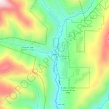
Name: Cowles topographic map, elevation, terrain.

Location: Cowles, San Miguel County, New Mexico, United States (35.79198 -105.67974 35.83198 -105.63974)

Average elevation: 8,855 ft

Minimum elevation: 8,031 ft

Maximum elevation: 10,102 ft

San Miguel County trails, hiking, mountain biking, running and outdoor activities

Other topographic maps

Click on a map to view its topography, its elevation and its terrain.

Conchas Dam

United States > New Mexico > San Miguel County > Conchas

Average elevation: 4,196 ft

Gear up for your next adventure:

🧢Sun Protection Hats - Wide-brimmed and UPF-rated hats for high-altitude sun safety
🎒Hydration Pack - Hands‑free water reservoir for long hikes
🪓Survival Multi‑Tool - Versatile tool for camp and trail tasks
🗃️Trail First Aid Kit - Essential kit for outdoor injuries and emergencies
🥘Titanium Cookware - Durable, featherlight pots and pans for backpacking

As an Amazon Associate, this site earns from qualifying purchases at no extra cost to you.