Geolocate

Sacaba topographic map

Click on the map to display elevation.

About this map

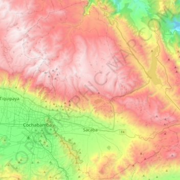
Name: Sacaba topographic map, elevation, terrain.

Location: Sacaba, Larati Grande, Chapare, Cochabamba, Bolivia (-17.50801 -66.18971 -17.13294 -65.79297)

Average elevation: 11,191 ft

Minimum elevation: 7,028 ft

Maximum elevation: 15,010 ft

Gear up for your next adventure:

🧼Biodegradable Camping Soap - Eco‑friendly soap for outdoor hygiene
🧤Tactile Hiking Gloves - Keep hands warm while operating GPS and smartphone screens
🥩Freeze-Dried Meals - Nutritious and lightweight food for remote expeditions
📚Navigation Handbooks - Master the art of reading topographic maps and using a compass
🗺️Topographic Maps - Detailed topo maps for hiking, exploring and outdoor navigation

As an Amazon Associate, this site earns from qualifying purchases at no extra cost to you.