
Sabang topographic map
Click on the map to display elevation.
About this map
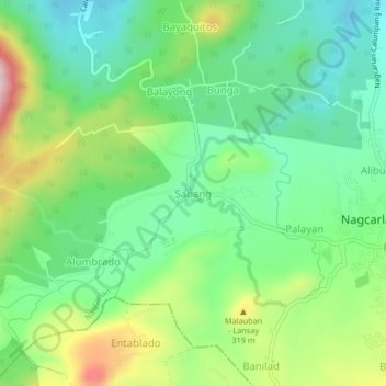
Name: Sabang topographic map, elevation, terrain.
Location: Sabang, Nagcarlan, Laguna, Calabarzon, 4002, Philippines (14.11923 121.37384 14.15923 121.41384)
Average elevation: 682 ft
Minimum elevation: 361 ft
Maximum elevation: 1,309 ft
Other topographic maps
Click on a map to view its topography, its elevation and its terrain.
Mounts Banahaw–San Cristobal Protected Landscape
Philippines > Laguna > Nagcarlan
Average elevation: 2,320 ft