
Westerly topographic map
Click on the map to display elevation.
About this map
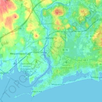
Name: Westerly topographic map, elevation, terrain.
Location: Westerly, South County, Rhode Island, United States (41.30358 -71.89242 41.41992 -71.73078)
Average elevation: 62 ft
Minimum elevation: -10 ft
Maximum elevation: 322 ft
South County trails, hiking, mountain biking, running and outdoor activities
Other topographic maps
Click on a map to view its topography, its elevation and its terrain.
Asa Pond Dam
United States > Rhode Island > South County > South Kingstown > Peacedale
Average elevation: 115 ft
Asa Pond Dam
United States > Rhode Island > South County > South Kingstown > Peacedale
Average elevation: 115 ft
Wakefield
United States > Rhode Island > South County > South Kingstown > Wakefield
Average elevation: 75 ft