
Make a donation
Gear up for your next adventure:
As an Amazon Associate, this site earns from qualifying purchases at no extra cost to you.
Bikini Atoll topographic map
Click on the map to display elevation.
Make a donation
Gear up for your next adventure:
As an Amazon Associate, this site earns from qualifying purchases at no extra cost to you.
Bikini Atoll
There are 23 islands in the Bikini Atoll; the islands of Bokonijien, Aerokojlol, and Namu were vaporized during the nuclear tests. The islands are composed of low coral limestone and sand. The average elevation is only about 7 feet (2.1 m) above low tide level. The total lagoon area is 229.4-square-mile (594.1 km2). The primary home of the islanders was the most northeast and largest islet, Bikini Island, totaling 586 acres (237 ha) and 2.5 miles (4.0 km) long.
Make a donation
Gear up for your next adventure:
As an Amazon Associate, this site earns from qualifying purchases at no extra cost to you.
About this map
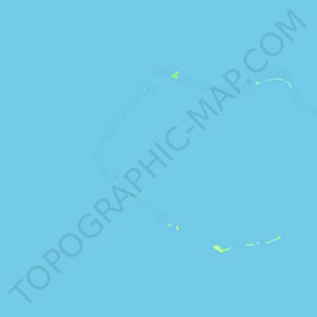
Name: Bikini Atoll topographic map, elevation, terrain.
Location: Bikini Atoll, Kili, Ralik Chain, Marshall Islands (11.49268 165.19317 11.71628 165.57284)
Average elevation: 0 ft
Minimum elevation: 0 ft
Maximum elevation: 66 ft
Make a donation
Gear up for your next adventure:
As an Amazon Associate, this site earns from qualifying purchases at no extra cost to you.
Other topographic maps
Click on a map to view its topography, its elevation and its terrain.
Make a donation
Gear up for your next adventure:
As an Amazon Associate, this site earns from qualifying purchases at no extra cost to you.