
Make a donation
Gear up for your next adventure:
As an Amazon Associate, this site earns from qualifying purchases at no extra cost to you.
Myponga topographic map
Click on the map to display elevation.
Make a donation
Gear up for your next adventure:
As an Amazon Associate, this site earns from qualifying purchases at no extra cost to you.
About this map
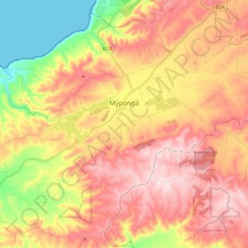
Name: Myponga topographic map, elevation, terrain.
Average elevation: 807 ft
Minimum elevation: 0 ft
Maximum elevation: 1,460 ft
Make a donation
Gear up for your next adventure:
As an Amazon Associate, this site earns from qualifying purchases at no extra cost to you.
Other topographic maps
Click on a map to view its topography, its elevation and its terrain.
Myponga River
Australia > South Australia > The District Council of Yankalilla > Myponga > Myponga Beach
Average elevation: 453 ft
Kalumunda Forest Reserve
Australia > South Australia > The District Council of Yankalilla
Average elevation: 869 ft
Mount Hayfield
Australia > South Australia > The District Council of Yankalilla
Average elevation: 912 ft