
Make a donation
Gear up for your next adventure:
As an Amazon Associate, this site earns from qualifying purchases at no extra cost to you.
Eagle Pass topographic map
Click on the map to display elevation.
Make a donation
Gear up for your next adventure:
As an Amazon Associate, this site earns from qualifying purchases at no extra cost to you.
About this map
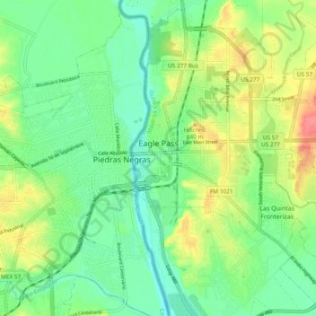
Name: Eagle Pass topographic map, elevation, terrain.
Location: Eagle Pass, Maverick County, Texas, 78852, United States (28.66333 -100.51175 28.74566 -100.42659)
Average elevation: 758 ft
Minimum elevation: 673 ft
Maximum elevation: 906 ft
Maverick County trails, hiking, mountain biking, running and outdoor activities
Make a donation
Gear up for your next adventure:
As an Amazon Associate, this site earns from qualifying purchases at no extra cost to you.
Other topographic maps
Click on a map to view its topography, its elevation and its terrain.
Eagle Pass
United States > Texas > Maverick County > Eagle Pass > Eagle Pass
Average elevation: 827 ft