
Portland topographic map
Click on the map to display elevation.
About this map
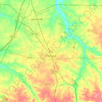
Name: Portland topographic map, elevation, terrain.
Average elevation: 778 ft
Minimum elevation: 623 ft
Maximum elevation: 955 ft
Sumner County trails, hiking, mountain biking, running and outdoor activities
Other topographic maps
Click on a map to view its topography, its elevation and its terrain.
Bluegrass Meadows
United States > Tennessee > Sumner County > Hendersonville
Average elevation: 512 ft
Lake Club Estates
United States > Tennessee > Sumner County > Hendersonville
Average elevation: 509 ft
Scottish Highlands
United States > Tennessee > Sumner County > Hendersonville
Average elevation: 515 ft
Scottish Highlands
United States > Tennessee > Sumner County > Hendersonville
Average elevation: 515 ft
Curtiswood
United States > Tennessee > Sumner County > Hendersonville > Curtiswood
Average elevation: 472 ft