
Make a donation
Gear up for your next adventure:
As an Amazon Associate, this site earns from qualifying purchases at no extra cost to you.
Monte Scuro topographic map
Click on the map to display elevation.
Make a donation
Gear up for your next adventure:
As an Amazon Associate, this site earns from qualifying purchases at no extra cost to you.
About this map
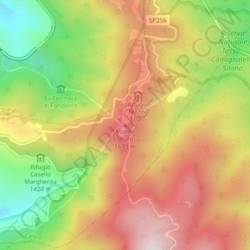
Name: Monte Scuro topographic map, elevation, terrain.
Location: Monte Scuro, Celico, Cosenza, Calabria, 87052, Italia (39.32988 16.39615 39.32998 16.39625)
Average elevation: 4,905 ft
Minimum elevation: 3,825 ft
Maximum elevation: 5,843 ft
Make a donation
Gear up for your next adventure:
As an Amazon Associate, this site earns from qualifying purchases at no extra cost to you.
Other topographic maps
Click on a map to view its topography, its elevation and its terrain.
Lago di Cecita
Italia > Calabria > Cosenza > Celico
Detto anche Mucone, ricade nei comuni di Spezzano della Sila (con la località di Camigliatello Silano), Longobucco e Celico. È situato a un'altitudine di 1 143 metri s.l.m. ed è il più grande dei laghi dell'altopiano silano, con una capacità d'acqua di 108 milioni di metri cubi.
Average elevation: 3,891 ft