
Thank you for supporting this site ❤️
Make a donation
Make a donation
Gear up for your next adventure:
As an Amazon Associate, this site earns from qualifying purchases at no extra cost to you.
Wildspitze topographic map
Click on the map to display elevation.
Thank you for supporting this site ❤️
Make a donation
Make a donation
Gear up for your next adventure:
As an Amazon Associate, this site earns from qualifying purchases at no extra cost to you.
About this map
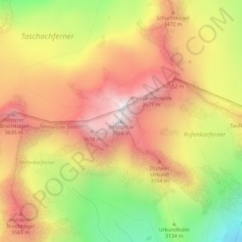
Name: Wildspitze topographic map, elevation, terrain.
Location: Wildspitze, Sölden, Bezirk Imst, Tyrol, 6458, Austria (46.88519 10.86723 46.88529 10.86733)
Average elevation: 10,774 ft
Minimum elevation: 8,881 ft
Maximum elevation: 12,247 ft
Thank you for supporting this site ❤️
Make a donation
Make a donation
Gear up for your next adventure:
As an Amazon Associate, this site earns from qualifying purchases at no extra cost to you.