
Make a donation
Gear up for your next adventure:
As an Amazon Associate, this site earns from qualifying purchases at no extra cost to you.
Burgrain topographic map
Click on the map to display elevation.
Make a donation
Gear up for your next adventure:
As an Amazon Associate, this site earns from qualifying purchases at no extra cost to you.
About this map
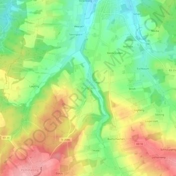
Name: Burgrain topographic map, elevation, terrain.
Location: Burgrain, Isen, Landkreis Erding, Bayern, 84424, Deutschland (48.16860 12.02873 48.20860 12.06873)
Average elevation: 1,844 ft
Minimum elevation: 1,654 ft
Maximum elevation: 2,067 ft
Make a donation
Gear up for your next adventure:
As an Amazon Associate, this site earns from qualifying purchases at no extra cost to you.
Other topographic maps
Click on a map to view its topography, its elevation and its terrain.
Erding
Deutschland > Bayern > Landkreis Erding > Erding
Zunächst wird das Trinkwasser zum Hochbehälter bei Lupperg auf 530 Metern Höhenlage gepumpt 48.239511.8689. Dieser wurde 1982 gebaut und hat ein Fassungsvermögen von 10.000 m³. Er dient der Druckerhaltung im Netz und puffert Bedarfsspitzen ab. Über eine 7,3 Kilometer lange Leitung mit 60 cm Durchmesser…
Average elevation: 1,509 ft
Dorfen
Deutschland > Bayern > Landkreis Erding
Adlstraß | Aich | Aichmühle | Algasing | Altweg | Angerhäusl | Anning | Anzing | Bachmaiertal | Bachzelten | Berg | Bergham | Bernöd | Bichl | Birkenhof | Bonesmühle | Brandlhub | Brandstätt | Breitenloh | Brodshub | Brunau | Dorfen | Dürneibach | Eck bei Dorfen | Eck bei Hinterberg | Eglafing | Eibach…
Average elevation: 1,611 ft
Make a donation
Gear up for your next adventure:
As an Amazon Associate, this site earns from qualifying purchases at no extra cost to you.
Taufkirchen
Deutschland > Bayern > Landkreis Erding
Naturräumlich gehört die Gemeinde zum tertiären Isar-Inn-Hügelland; die Gemeinde liegt im Erdinger Holzland an der Großen Vils. Die Flussniederung der Vils hat eine Höhenlage zwischen 482 m ü. NHN bei Hörgersdorf und 453 m ü. NHN in den Mooswiesen bei Winkel.
Average elevation: 1,598 ft
Make a donation
Gear up for your next adventure:
As an Amazon Associate, this site earns from qualifying purchases at no extra cost to you.
Erding
Deutschland > Bayern > Landkreis Erding
Zunächst wird das Trinkwasser zum Hochbehälter bei Lupperg auf 530 Metern Höhenlage gepumpt 48.239511.8689. Dieser wurde 1982 gebaut und hat ein Fassungsvermögen von 10.000 m³. Er dient der Druckerhaltung im Netz und puffert Bedarfsspitzen ab. Über eine 7,3 Kilometer lange Leitung mit 60 cm Durchmesser…
Average elevation: 1,526 ft
Make a donation
Gear up for your next adventure:
As an Amazon Associate, this site earns from qualifying purchases at no extra cost to you.
Lengdorf
Deutschland > Bayern > Landkreis Erding
Nördlich des Hauptortes durchquert auf Höhe des Ortes Thann die Bahnstrecke München–Simbach die Gemeinde in West-Ost-Richtung.
Average elevation: 1,640 ft
Make a donation
Gear up for your next adventure:
As an Amazon Associate, this site earns from qualifying purchases at no extra cost to you.
Make a donation
Gear up for your next adventure:
As an Amazon Associate, this site earns from qualifying purchases at no extra cost to you.
Make a donation
Gear up for your next adventure:
As an Amazon Associate, this site earns from qualifying purchases at no extra cost to you.
84416
Deutschland > Bayern > Landkreis Erding > Taufkirchen > Aham > Hilpolding
Average elevation: 1,591 ft