
Burscheid topographic map
Interactive map
Click on the map to display elevation.
About this map
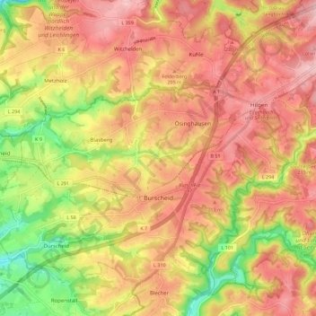
Name: Burscheid topographic map, elevation, terrain.
Average elevation: 597 ft
Minimum elevation: 253 ft
Maximum elevation: 827 ft
Other topographic maps
Click on a map to view its topography, its elevation and its terrain.
Bergisch Gladbach
Deutschland > Nordrhein-Westfalen > Rheinisch-Bergischer Kreis
Bergisch Gladbach, Rheinisch-Bergischer Kreis, Nordrhein-Westfalen, Deutschland
Average elevation: 377 ft
Sürth
Deutschland > Nordrhein-Westfalen > Rheinisch-Bergischer Kreis > Kürten
Sürth, Kürten, Rheinisch-Bergischer Kreis, Nordrhein-Westfalen, Deutschland
Average elevation: 781 ft
Overath
Deutschland > Nordrhein-Westfalen > Rheinisch-Bergischer Kreis
Overath, Rheinisch-Bergischer Kreis, Nordrhein-Westfalen, 51491, Deutschland
Average elevation: 617 ft