
Edgewood topographic map
Click on the map to display elevation.
About this map
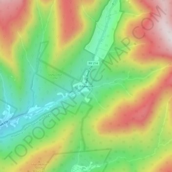
Name: Edgewood topographic map, elevation, terrain.
Average elevation: 2,484 ft
Minimum elevation: 1,467 ft
Maximum elevation: 3,763 ft
Greene County trails, hiking, mountain biking, running and outdoor activities
Other topographic maps
Click on a map to view its topography, its elevation and its terrain.
Onteora Pond Dam
United States > New York > Greene County > Town of Hunter
Average elevation: 2,392 ft
Haines Falls
United States > New York > Greene County > Town of Hunter > Haines Falls
Average elevation: 2,057 ft
Platte Clove
United States > New York > Greene County > Town of Hunter > Platte Clove Bruderhof
Average elevation: 1,886 ft