
Thank you for supporting this site ❤️
Make a donation
Make a donation
Gear up for your next adventure:
As an Amazon Associate, this site earns from qualifying purchases at no extra cost to you.
Culebras topographic map
Click on the map to display elevation.
Thank you for supporting this site ❤️
Make a donation
Make a donation
Gear up for your next adventure:
As an Amazon Associate, this site earns from qualifying purchases at no extra cost to you.
About this map
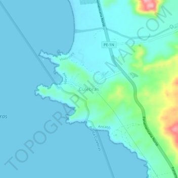
Name: Culebras topographic map, elevation, terrain.
Location: Culebras, Provincia de Huarmey, Áncash, Perú (-9.97017 -78.24209 -9.93017 -78.20209)
Average elevation: 66 ft
Minimum elevation: 0 ft
Maximum elevation: 522 ft
Thank you for supporting this site ❤️
Make a donation
Make a donation
Gear up for your next adventure:
As an Amazon Associate, this site earns from qualifying purchases at no extra cost to you.