
Make a donation
Gear up for your next adventure:
As an Amazon Associate, this site earns from qualifying purchases at no extra cost to you.
Tobaccoville topographic map
Click on the map to display elevation.
Make a donation
Gear up for your next adventure:
As an Amazon Associate, this site earns from qualifying purchases at no extra cost to you.
About this map
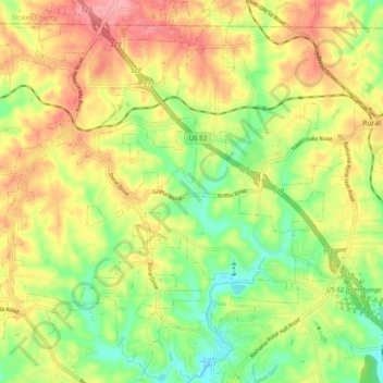
Name: Tobaccoville topographic map, elevation, terrain.
Location: Tobaccoville, Forsyth County, North Carolina, United States (36.18901 -80.40994 36.26329 -80.31148)
Average elevation: 948 ft
Minimum elevation: 784 ft
Maximum elevation: 1,115 ft
Forsyth County trails, hiking, mountain biking, running and outdoor activities
Make a donation
Gear up for your next adventure:
As an Amazon Associate, this site earns from qualifying purchases at no extra cost to you.
Other topographic maps
Click on a map to view its topography, its elevation and its terrain.
Atwood Acres
United States > North Carolina > Forsyth County > Winston-Salem
Average elevation: 791 ft
Make a donation
Gear up for your next adventure:
As an Amazon Associate, this site earns from qualifying purchases at no extra cost to you.
Stanleyville
United States > North Carolina > Forsyth County > Winston-Salem
Average elevation: 889 ft
Make a donation
Gear up for your next adventure:
As an Amazon Associate, this site earns from qualifying purchases at no extra cost to you.
Make a donation
Gear up for your next adventure:
As an Amazon Associate, this site earns from qualifying purchases at no extra cost to you.
Columbia Heights
United States > North Carolina > Forsyth County > Winston-Salem
Average elevation: 853 ft
Make a donation
Gear up for your next adventure:
As an Amazon Associate, this site earns from qualifying purchases at no extra cost to you.
Reynolda Village
United States > North Carolina > Forsyth County > Winston-Salem
Average elevation: 912 ft
Reynolda Village
United States > North Carolina > Forsyth County > Winston-Salem
Average elevation: 912 ft
Make a donation
Gear up for your next adventure:
As an Amazon Associate, this site earns from qualifying purchases at no extra cost to you.
Briarcliff Manor
United States > North Carolina > Forsyth County > Winston-Salem
Average elevation: 814 ft
Make a donation
Gear up for your next adventure:
As an Amazon Associate, this site earns from qualifying purchases at no extra cost to you.
West Highlands
United States > North Carolina > Forsyth County > Winston-Salem
Average elevation: 883 ft