Geolocate

Lodi topographic map

Click on the map to display elevation.

About this map

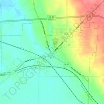
Name: Lodi topographic map, elevation, terrain.

Location: Lodi, Medina County, Ohio, United States (41.02447 -82.03442 41.04460 -81.98821)

Average elevation: 968 ft

Minimum elevation: 869 ft

Maximum elevation: 1,148 ft

Medina County trails, hiking, mountain biking, running and outdoor activities

Other topographic maps

Click on a map to view its topography, its elevation and its terrain.

Abbeyville

United States > Ohio > Medina County

Average elevation: 912 ft

Hinckley

United States > Ohio > Medina County

Average elevation: 1,083 ft

Litchfield

United States > Ohio > Medina County

Average elevation: 1,004 ft

Valley City

United States > Ohio > Medina County

Average elevation: 860 ft

Valley City

United States > Ohio > Medina County

Average elevation: 860 ft

Valley City

United States > Ohio > Medina County

Average elevation: 860 ft

Wadsworth

United States > Ohio > Medina County > Wadsworth

Average elevation: 1,129 ft

Gear up for your next adventure:

🪶Fire Starter Kit - Reliable fire starter for survival and camping
🔭Telescopic Hiking Pole - Adjustable pole for hiking stability
🪶Camp Gear Gift Set - Perfect gift bundle for outdoor fans
Backpacking Tent - Lightweight and durable tent for multi‑day hikes
🥤Water Filter Bottle - All‑in‑one filter bottle for safe hydration

As an Amazon Associate, this site earns from qualifying purchases at no extra cost to you.